
Cyclone Fina Strengthens as It Approaches NT Coastline, Landfall Expected Soon
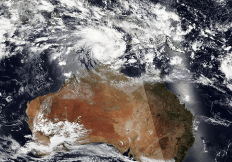
Tropical Cyclone Fina, currently a Category 1 cyclone, is gradually moving south over the Northern Territory’s Top End and is expected to strengthen before making landfall. The Bureau of Meteorology (BOM) has issued a cyclone watch alert for communities in north-west Arnhem Land and the Tiwi Islands, where Fina is likely to hit as a Category 2 cyclone at around 1am CST on Saturday morning.
As of the latest update, Fina has sustained winds of 75 km/h near its center, with gusts reaching 100 km/h. The cyclone is expected to continue on a south-west path through the Timor Sea over the coming days.
A warning zone stretches from Maningrida in the east to Cape Don on the Cobourg Peninsula, including Minjilang and Warruwi. Residents in the warning zone should take immediate action to secure property and prepare for the worsening conditions. A watch zone extends across the Tiwi Islands and Darwin, where people should prepare for possible action as the cyclone threat increases.
The cyclone's impact could be severe, with high winds, heavy rainfall, and possible flooding. Residents are advised to monitor BOM updates and prepare accordingly.