
Australia Experiences Unprecedented Weather Extremes on Summer's First Day with Scorching Heat and Record Cold
Australia's inaugural summer day has delivered starkly contrasting meteorological conditions across the continent, with the western regions experiencing dangerous heat waves while southeastern areas endure unseasonable arctic conditions and snowfall.
Western Australia's capital city experienced its hottest beginning to the summer season on record. Temperatures in Perth climbed to 39 degrees Celsius on Monday, surpassing the previous opening-day benchmark. The intensity of the heat continued escalating throughout the afternoon, with dozens of other locations across the western and southwestern regions facing similar dangerous temperatures.
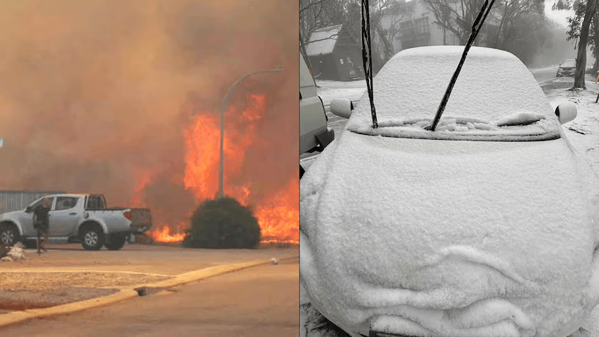
The extreme conditions have created hazardous circumstances for fire management personnel, who are actively battling a bushfire in a regional centre north of Perth. One residential structure has already been lost, and hundreds of additional properties remain under threat as the fire spreads across vulnerable terrain amid exceptionally hot, dry and windy conditions. Officials suspect the fire was deliberately ignited.
The regional municipality north of Perth recorded 42.2 degrees Celsius, marking the hottest opening to December in nearly a century. Coastal areas traditionally cooler during summer months have also experienced unseasonable warmth, with one coastal city reaching 36.2 degrees Celsius, its highest temperature since records commenced in 1907.
Simultaneously, the southeastern portions of the continent have plunged into deep winter-like conditions despite the official season change. A polar air mass tracking unusually far north from typical December paths has created widespread cold extending 10 to 15 degrees below seasonal norms across numerous locations spanning New South Wales, Victoria and Tasmania.
Alpine and mountainous regions have experienced particularly severe conditions, with snow falling across high-elevation zones. One alpine resort awakened to dusting of snow cover after overnight temperatures dropped to negative 0.9 degrees Celsius.
Multiple locations are tracking toward records for their coldest summer opening in recent history or decades. Metropolitan centres and major cities recorded notably depressed daytime temperatures. Australia's second-largest city registered just 16.1 degrees Celsius as its maximum temperature, narrowly escaping a temperature record from 1987, though wind-chill effects made conditions feel dramatically colder.
A meteorologist explained the atmospheric dynamics creating the frigid conditions: "Once you have a series of cold fronts, it really just keeps re-enforcing that colder air and you end up with a really deep layer of colder air that can just keep reducing the maximum temperature."
The wind component has intensified the perception of cold substantially. At one airport in the major southern city, the "feels like" temperature registered just 2.5 degrees Celsius despite the actual air temperature being 11.5 degrees Celsius.
"The wind-chill factor is creating particularly biting cold weather across Victoria," noted a senior meteorologist.
The nation's capital experienced its coldest opening to summer since 1994, while one regional Victorian city recorded its coldest opening since 1987. Tasmania's largest city registered temperatures reminiscent of conditions not seen since 1942.
The severe cold conditions represent continuation of an exceptionally chilly meteorological pattern that has dominated the southeastern region since early November. The preceding month delivered five separate snowfall events to mainland alpine regions as successive cold fronts repeatedly arrived from the Southern Ocean.
The western region's heat conditions, by contrast, reflect temperatures running 8 to 10 degrees Celsius above seasonal averages. Despite the record-breaking December opening temperatures, they remain substantially below historical all-time records for the month. The capital city's highest December temperature on record remains 44.2 degrees Celsius, recorded on Boxing Day in 2007.
The record cold in the southern metropolis, while notable for summer's opening, similarly falls short of the city's most extreme cold December maximum of 10.4 degrees Celsius, recorded in 1867.
Forecasters anticipate both extreme conditions will prove short-lived. The intense heat affecting the western state will gradually track eastward throughout the week, with a tongue of hot air from northern Australia pushing across inland western regions Tuesday and Wednesday. The heat surge is projected to peak across southeastern states Thursday, with major cities in that region forecast to reach approximately 33 degrees Celsius.
The remarkable variability characterizing summer's opening underscores the dynamic meteorological patterns accompanying seasonal transitions in the Southern Hemisphere.